
As technology continues to evolve, so do the tools available to engineers and legal teams as they analyze crashes, infrastructure failures, and liability disputes. Integrating these advanced technologies allows engineers to reconstruct events with unprecedented accuracy and provide courts with evidence-based insights.
Most recently, we’ve seen innovation in three major tool categories:
- Tort Liability Case Tools
- Documentation Tools
- Condemnation and Access Tools
Together, these can not only enhance efficiency but also boost the credibility of expert testimony to help lawyers build stronger arguments.
Tort Liability Case Tools
Tort liability cases often hinge on the ability to reconstruct events and demonstrate negligence or compliance with standards, such as those stemming from roadway design flaws, vehicle malfunctions, or driver errors. There are now tools available to leverage technology in a way that transforms how these cases are investigated and presented.
Unmanned Aerial Vehicles
One cornerstone tool is Unmanned Aerial Vehicles (UAVs), or drones, which have revolutionized crash reconstruction by enabling rapid, safe, and highly accurate data collection without having to close travel lanes. most flights last under ten minutes and produce 3D point clouds and orthorectified images with precision within a few inches.


With a comprehensive aerial view of the crash site, UAVs can reveal details like skid marks, debris patterns, and environmental factors that might contribute to liability. For instance, in highway tort cases, orthorectified aerials from drones can illustrate how poor signage or lane configurations led to a collision.
Vehicle Event Data Recorders
Often referred to as “black boxes,” vehicle event data recorders (EDRs) have been standard in most vehicles since 2013. They capture critical pre-impact data such as speed, steering input, and braking activity for up to five seconds before a crash. This information is invaluable in tort cases to establish driver behavior or vehicle performance issues.

Upcoming changes mandated by the National Highway Traffic Safety Administration (NHTSA) for model year 2027 will expand this to 20 seconds of pre-impact data at 10 Hz frequency. This update also calls for incorporating details such as turn signal use, rear seat occupancy, transmission gear position, and individual wheel speeds.
Some manufacturers, like Tesla and GM, already provide extended datasets and even dashcam videos.
Video Surveillance and AI-Based Near Miss Detection
Video surveillance tools add a dynamic layer to tort analyses. Beyond capturing the accident itself, they also document:
- Circulation patterns
- Vehicle types
- Parking demand
- Traffic volumes
This helps experts model pre-crash conditions and identify systemic issues, such as overcrowded intersections leading to negligence claims.
Another component to this is near-miss AI technology, including systems like Quality Counts’ DataLens, that use artificial intelligence for conflict analysis. By detecting close calls that don’t result in crashes, it provides predictive insights into potential liabilities.

Documentation Tools
Accurate documentation is the backbone of any forensic transportation engineering case. Recent innovations have made data collection faster, more precise, and more accessible. When combined with other tools, like drone aerials or EDR data, these documentation methods create a seamless evidentiary chain.
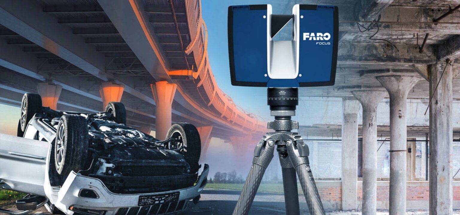
FARO Laser Scanning
Ideal for large-scale crash scenes, FARO scanners deliver 2mm precision that creates detailed 3D models of crash scenes, infrastructure, or entire roadways. Scanning takes approximately one hour, but the results are comprehensive. FARO scanners can produce models that show elements like pavement conditions or guardrail placements that might indicate negligence.

In tort cases involving physical infrastructure, FARO scans can visually demonstrate whether design flaws were foreseeable.
LIDAR-Enabled Mobile Devices
Today, thanks to modern iPhones and iPad Pros, the ability to capture critical, high-quality data on-site with minimal setup is readily available. These devices feature LIDAR sensors that enable quick scans with 5mm precision in under five minutes, reducing reliance on specialized equipment.
Experts can capture vehicle damage, tire tracks, or scene layouts with ease, generating point clouds similar to those from drones. Demonstrations often highlight their utility in small-scale reconstructions, such as scanning toy models to simulate real crashes, which translates to courtroom visuals.

The integration of advanced case study tools into forensic transportation engineering has transformed how tort liability and documentation are handled. UAVs, EDRs, and AI analytics provide robust insights into crash causation, while laser scanning and LIDAR-equipped devices guarantee precise site documentation. Together, these technologies not only improve technical accuracy but also enhance storytelling in the courtroom, bridging the gap between engineering analysis and legal advocacy.
Condemnation and Access Tools
In forensic transportation engineering, condemnation and access cases center on how public projects affect private property. These cases often involve property rights, eminent domain, and whether changes to roads or infrastructure significantly limit how a property can be accessed or used.

With the right tool, experts help show when access has been materially harmed, such as reduced visibility, more difficult entry and exit, or loss of parking. This may qualify a property owner for compensation under established legal standards.
Four Critical Ways These Tools Support Expert Analysis
Site Documentation and Historical Evidence
Google Earth and historical aerial imagery are essential for establishing pre- and post-project conditions. Time-sequenced imagery allows experts to document driveway closures, access reconfigurations, visibility changes, and circulation impacts over time.
Additionally, video documentation, captured before and after a project, provides real-world evidence of how a site is actually used. Video footage shows vehicle movements, loading activity, and circulation patterns, which can demonstrate operational changes that are difficult to convey through plans alone.
Circulation and Operational Analysis
Forensic transportation experts analyze circulation patterns and vehicle types to understand how different users (passenger vehicles, delivery trucks, service vehicles, etc.) access a property. These analyses evaluate travel distances, access efficiency, and maneuverability to determine whether project changes materially impair reasonable access.
Experts also use parking demand analysis quantifies parking needs and identifies losses resulting from a project. Parking reductions often have direct operational and economic consequences, making this tool critical in inverse condemnation claims.
Modeling, Simulation, and Visual Exhibits
AutoTurn vehicle-swept path analysis is used to test whether vehicles can safely and reasonably maneuver on a site after project changes, particularly for larger vehicles.
To communicate findings clearly, engineers prepare 2D circulation diagrams and 3D site simulations that visually illustrate access constraints and circulation changes. These exhibits help judges and juries understand complex access issues in a clear, intuitive way.
Field Testing and Mitigation Support
When appropriate, on-site vehicle testing (truck rodeos) is conducted to validate simulation results and confirm real-world performance. Experienced transportation engineers also use these findings to develop mitigation strategies, such as alternative access points or circulation adjustments, that may reduce impacts and support fair resolution.
Turning Tools into Defensible Evidence
The evolution of tools in forensic transportation engineering is revolutionizing case studies across tort liability, documentation, and condemnation contexts. By combing everything from Google imagery and circulation analysis to UAVs and advanced simulations, forensic transportation experts can take technical findings and translate them into clear, credible evidence.